Saturday, 10 November 2012

A walk to Grasmoor from Buttermere

On Thursday 8th November we were a group of three, and were determined for a decent walk. Ruth having joined the two of us has recently, has decided to work her way through the Wainwright Peaks and with 140 for her still to go at we were spoilt for choice. We decided to head for Buttermere with the intention of going up Whiteless Pike, onto Wandope, Grasmoor then perhaps aim for Hopegill Head, the goal being Whiteside and then Rannerdale Knotts. We parked on the Newlands Valley Road, just above the church, a favourite 'free' park unleashed the dogs and headed for the Mill Beck track to Whiteless Breast.

 
Whiteless Breast leading onto it's Pike.

 
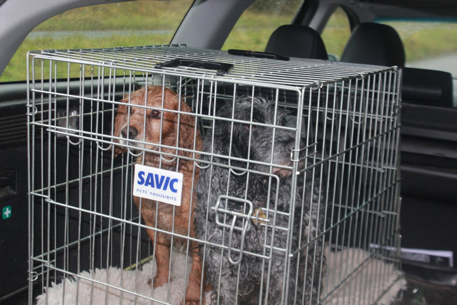
'The Beast' awaits uncaging. Dylan is already on his wanders.

 
Looking back as we make our way up Mill Beck.
 
Above are two photographs from car park area and this is a Godsend in Buttermere, a reason we walk there often. The third photograph is the oak coppice and the autumn colours were beautiful. The calmness here was to be in contrast for the weather yet to come, although it was clear the weekend snow had disappeared from the fells, which was at least far better than Mondays outing on Helvellyn. For those that don't know the area you are rewarded very early into this walk with a beautiful view toward Squat Beck and to Rannerdale itself as you just pass Low Bank.

 
Crummock Water with Lowswater beyond, looking down Squat Beck.

 It was here that the wind began to bite and the fine drizzle turned to cold biting rain that did not relent for three hours. I know this route well and you can't go wrong following the well worn path for Whiteless Pike.
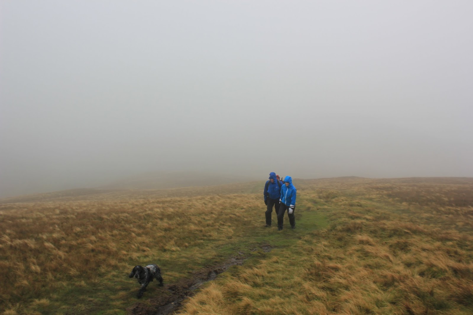
 
A change in the weather.

 
Ruth sitting on the summit of Whiteless Pike, to stand she would have been blown off.

 We had the 'I was here' photo of Ruth on the summit and headed further on for Wandope. Here the paths begin to multiply but even in cloud and rain it is easy to find bearing to the right to keep the edge in sight. It really was bitter cold and we carried on for Grasmoor though if you just hold the edge you will eventually reach Crag Hill, which was not our destination. We branched off to the left and quickly hit the path realising we were part up the Crag Hill path leading from Grasmoor and needed to drop a little for the hause between the two fells. The push up Grasmoor is a warming climb, not too steep and good underfoot, but at a decent pace it gets the heart pumping. Don't be fooled to think you are at the summit when you reach the first cairn as the high point is still some 800m ahead and be careful, this fell is barren on top, a moonscape, but wander aimlessly and you will reach corries and steep screes. The Lad Hows path is difficult to find if you are returning to Crummock down it, but once on it you can't really go wrong. We had decided to eat our bait on Grasmoor as the summit cairn is like a spiral, swirls leading off and you can find some arm that affords protection from the wind. This fell is the highest one on the whole group and is open to The Irish Sea wind, fed from The Atlantic wind. There was nothing one could describe as pleasant about this outing and after our food and hot drink we decided that the next fell of Whiteside was too much pain for little gain and plumbed for the Lad Hows route. We still had Rannerdale Knotts to climb so there was walking still to do and didn't feel guilty about the shorter route.

 
Ruth and Steve, well wrapped at the cairn. A rare appearance by Holly as there is food out.
 
We headed down the Lad Hows, quickly losing height and it was noticeable that the temperature picked up and the wind abated as we began to be sheltered by the more western fells. It seemed no time at all before we were on the valley floor, walking nondescript low fell bracken which in spring changes to one of the Lake districts best displays these being The Rannerdale Bluebells, a perfectly blue carpet in open valley terrain. We moved through the bracken and over the wooden bridge that straddles Squat Beck. We had picked our route to the summit of Rannerdale Knotts as we had descended Lad Hows. Rather than return to the road and go up the tourist path, we decided to head for the OS marked Right of Way route that skirts the Dale How rock projection and denoted by a substantial dry stone wall. This was steep and we found no actual path, though by turning I made a mental note regarding where I was going to view 2013's blue display in the valley floor and it would be from here. We clambered on, walking as a description doesn't suit the terrain we covered as it was 'three points of contact' for a good part of it.


Three points of contact route, well it was different.
 
 
Crummock with the Mosser(pronounced Mozzer) Fells of Fellbarrow and Low Fell in the distance, The Solway Firth and Scotland beyond.
 
We finally reached the top of this small but tough fell and it was commented that it was the most difficult part of the walk. It was worth the effort though, to learn something new about an area that we know very well and in high season I will use this instead of the worn tourist routes to the top.


Once at the cairn the views deep into Butteremere open up to you and you have to stop and soak up the beauty of it. I believe this valley was the last place in what is England to be finally conquered after The Norman Conquest, through it's inaccessibility in both geography, terrain and the wild locals of course. Now it is a serene location to rest a troubled mind and soul, as tourists do.
 It was time for three local dwellers to rest their souls and that had been decided to be in The Fish Hotel, Buttermere, a parking place for the soul of old but we had recently defaulted to The Kirkstyle Inn, still a change is as good as a rest. I had a pint of Marstons Armistice( it's 11th of 11th tomorrow) and a pint of Snecklifter. Both well kept, though they knocked the lights out on us at their afternoon closing time, I hate that. A good outing in the cold wind and rain of 13kms with 1300m ascent.
 My next outing is tomorrow, 11th day of 11th month and will be on Great Gable. To be anywhere else as a fell walker on this day would be wrong, excluding other points of tribute, but this fell is the one for me to pay my respects.


Wednesday, 7 November 2012

Helvellyn From The Other Side.

For years we've tracked up to the summit of Helvellyn by various routes from Glenridding, usually taking in the spectacular edges of Striding and Swirral. In good weather these are safe and you are rewarded with magnificent views of Ullswater on this journey. We have various adhoc team members,  so any group is dependant on who is not working. This usually means that someone has not done the edges and as we the usual members are experienced on them, we introduce yet another novice to Striding & Swirral and feel all the better in our hearts for it. Oh, there are some cracking pubs on that side too. Though good beer always features high in our walk plan you can settle into a safe zone and eventually it becomes boringly the same.
 On Tuesday 6th November there were just the two core members, Steve & myself and the two cockers Dylan & Holly(The Beast). Now Dylan is just a dog and can't read but apparently when told I had been spelling his name wrong(Dillon) he was mortified and asks that it be corrected, which I just have; sorry boy.
We were unable to get out on our normal walking Monday, which was good because the weather was beautiful and where's the fun in that? Tuesday was looking far worse so we plumbed for that and picked a route from Wythburn Church car park to head onto Nethermost Pike, Helvellyn, Raise, down Sticks Pass and along the footpaths and permitted paths back to the Church, avoiding the A591 road in it's entirety. Neither of us had done this route up or the route down so some of it was virgin territory for us and that was the interesting section to us. The dogs couldn't have cared, they just wanted unleashed. Once at the car park we saw the £7 charge, looked at each other and thought in unison 'That's two pints'! so we returned to the more northern Swirls car parks and found these still priced the same. The dogs were going bananas by this time, wondering what was going on.


A couple of tourists
Helvellyn, from Swirls.
I remembered the lay-by between here and The Kings Head Hotel and we parked there for nothing and admired the views offered by a valley I often drive down, but rarely stop in. As we got out of the car we saw a sight that helped make the day, two Llamas grazing away in the field, when all you expect to see in Lakeland is Herdwicks, Herdwicks and more Herdwicks.
 We got kitted up (without my waterproof leggings, bad decision) and set off for the permitted path to Wythburn Church. This is a 3.5km larch plantation walk and if you follow the dark blue permitted path arrows, roughly half is along the woodland roads and half across a rough terrain track, though well worn. We are not natural 'valley bottom' walkers, we usually take a direct route to the summit of something, though to make a return route here you really have to walk the valley floor. This had the advantages of stretching in the old Achilles tendons and offering views of Thirlmere from different vantage points than I have seen before.

 
To walk a pasture and follow a meandering river is serene but there is just something magical being among mountains in flood and watching and taking the time to listen to water pouring off a fell.


Thirlmere Straining Well. This reservoir was built to supply Manchester and is gravity fed. It was the site of two former lakes Wythburn Water and Leathes Water. For further facts on this magnificent feat of engineering try http://www.engineering-timelines.com/scripts/engineeringItem.asp?id=854

 
Whelpside Gill.

After an hour we were at the crossroads of the valley path and our original intended path from the church, this was marked by a four handed marked fingerpost sign. We turned left and ascended steeply by a 'fix the fells' route to Nethermost Pike where we quickly left the plantation behind and got onto a fell path proper. I had hoped for a light rain and had chanced walking without waterproof trousers, this decision was a bad one for me. The higher we climbed, the more unrelenting was the wind and rain and we quickly achieved the snowline.

 
Dylan with not a care in the world.
 
This path is open to the westerly winds and you feel it all the way up. Come from the Glenridding direction and in general you are sheltered from the wind until you are on the summit; here you feel it once you leave the tree line and the higher you get the harder and colder it blows. By the time I was on the summit I wished I had put the trousers on. There wasn't many photo opportunities on the way up and why would you? I was protective of my camera and one may as well look at a grey wall than any photo I would have taken. Once on the summit though I thought I would take a couple of photographs to show the conditions.

 
Here you see the plaque for the plane that landed on Helvellyn and the cross shelter ahead.

 
This is from the shelter and looking toward the Striding Edge route down to Glenridding.

You can see from the above that conditions were terrible to navigate in. This is a very popular fell but on this day we saw only one other person at the summit when you normally have to fight for a seat in the shelter. We donned some extra clothing while we ate some food and had a few hot drinks and decided to shorten the route via Browncove Crags and off we set. Through recognition of the cairn for Swirral Edge we orientated ourselves along the correct path for the crags and made some rapid progress until we were out of the cloud line, the wind and the temperature slowly improving. This was good because my boots were wet and I couldn't feel my toes or fingers. Thirlmere became visible and it's always nice to see the car as the final aim point of the walk.

 
Thirlmere with Raven Crag on the far shore, to the right.

This was a tricky 'fix the fells' descent on this path, in wet and hard snow it is easy to tumble, but we eventually got to the point where the gradient eased. We crossed the bridge over Helvellyn Gill and were on the valley floor.

 
Helvellyn Gill and nearly journey's end.

The dogs were put on the leads for the very short road walk to the cars and when placed in the cage, looked a little forlorn to have only covered 12km with 950m ascent.

 
'We aren't happy'.

 A quick change at the roadside into normal attire and we were off to the pub, deciding to try The Kings Head Hotel, a few hundred yards away. This pub was a classic at one time with it's roadside look of a place of safety and comfort for those travellers of old in a bygone age. One expects some reflection of that with modern facilities in a modern age but the fabric of this seems to have been ripped out and is reminiscent of a city centre 'new age eater'. Though we knew what we would see having been once before, I hoped we could steal ourselves to remain; we couldn't. We made a quick about turn and headed up St. John's In The Vale for The White Horse on A66 and a brilliant decision this was.

 
Heaven.

 This was shut a while ago so I've always driven past it but on entering, there was a good log fire, local people and three pumps of Corby 'Blonde', Heskett 'Skiddaw' and Derwent Brewery's 'Carlisle State Bitter'. We both had a Corby and I then polished off a Skiddaw while Steve plumbed for The Carlisle State Bitter (It gets it's name from the government managing the brewery as the munitions for WWI were made near Carlisle and the government couldn't have drunken workers, so controlled the liquor trade http://news.bbc.co.uk/dna/place-lancashire/plain/A644645 ) Time for home and a good soak in the shower to warm up.
 A short walk for us, but a new route onto Nethermost and down to Swirls, so it builds on the knowledge. At cold windy day but still enjoyable for that, it puts air in the lungs and makes the heart pound, easing the conscience when drinking beer, it's been paid for in sweat. Out for another walk tomorrow, I hope the weather is better, but whatever it throws at us, we'll be out and hopefully have other company.

Sunday, 4 November 2012

The Last Wainwright and a Celebration.

During the course of this my first year of retirement, I've been assisting a friend to complete the Wainwright Peaks. We were joined part way through by another retiree who initially joined us for fitness, then assessed how many he had to do and decided to complete the others also. This left us in the situation where we they had both done similar numbers, but separate fells, so it's been a hell of a walking schedule to try and bring some unity to what needed completed. My original colleague then had an accident which has rendered him out of action for about three month, so this left the two of us still standing to finish the round. It was never a classic start so it wasn't going to be a classic end either. The end was to be Mungrisedale Common and Wainwrights dismissive comments are well known, yet it is in the list and therefor has to be done. Now Blencathra's main fell body has had my footfall on hundreds of occasions by all routes known to man, except Mungrisedale Common and I was about to find out why.
 Before viewing the Wainwright list I would not even recognised it as a fell though knowing that area well I did expect the views to be good from it's 'summit' cairn. To use the word 'summit' is an insult to other fells for without the cairn one would not know what to aim for and in mist could wander aimlessly trying to find a point to say you had actually been there.
 We had a plan; set off from Mungrisedale, head via The Tongue path, arc round Bannerdale Crags to the Hause between Bannerdale  and Atkinson Pike(the lower section of Blencathra's 'Saddle') and head out for Mungrisedale Common cairn. There were to be five of us, Steve, Ruth, Karl, Catherine and myself, not to forget the two dogs, Dillon and Holly 'The Beast' also making numbers up. It was tight in the estate but we all crammed in, backpacks and a change of clothing included, well you've got to look smart(ish) in the pub.
 After half an hours driving we parked at the village hall as the small car park was already full. This route to Blencathra is a favourite and in poor weather, an exercise walk as I know it intimately.

 
The Mill Inn with Souther Fell, legend of The Ghost Army.
 
 
Heading for The Tongue path.

 
The Tongue, Bowscale Fell to the right with Bannerdale to the left, Glenderamackin river to the left of the path.
 
Although Souther Fell was not on our route I mention this as a scene of local legend and folklore. Such stories say as much about an area as does the landscape and a knowledge of both for visitors is essential. Souther Fell is renowned for it's Ghost Army and for further reading you can check this knowledgeable account. http://esmeraldamac.wordpress.com/2011/01/19/the-ghostly-procession-at-souther-fell/
 As you leave the hamlet of Mungrisedale you get the above view of The Tongue. It makes me snigger every time I see it as it is the classic, symmetrical mountain we all start off painting at school at the tender age of 5yrs. The weather was sunny though not altogether clear and soon we were about to feel it's turn.

 
Looking back on Mungrisedale from below The Tongue.

 
Again looking back, this is the path up The Tongue whose summit can be viewed on the left, Souther fell receding in the centre of shot.

 
Bannerdale Crags corrie path.
 
The above three photographs show the abrupt change in the weather we experienced with some of the first snows of The Lakes autumn season. You are protected by the Skiddaw Massif as you ascend The Tongue path, but once at the top are then exposed to the biting wind and it's time for further layers of clothing to cover all parts of the body. We branched off just before Bannerdale summit and headed for the path intersection below Atkinson Pike, hoping for the weather to clear so Sharp Edge would come into view.

 
Atkinson Pike, Foule Crag and Sharp Edge.

 
The intended path for Mungrisedale Common, Skiddaw in cloud, Great Calva summit on the right.

The weather did abate and on cue the Edge came into view framed by the morning low autumn sun. Catherine had been here with us once before but had to settle for descriptions, now she could see it and all the better for that, she just needs to actually do it now, but not today. The third photo is our path to The Common and if you can see a summit here you're a better man than me, though when walking you begin to pick out a dot on the horizon that is the cairn.

 
Karl and Ruth striding out along the 'path'

 
Looking north to High Pike (left), Carrock Fell (centre) and Bowscale(right).
 
This summer has been the wettest on record, the autumn has been little better and yes you've guessed it, the path was a peaty quagmire. With good boots that thankfully didn't sink below the lace ties, well not mine anyway, we waded our way to the cairn. This is no exaggeration and unless to really have to, I recommend you save this for a period of long dry weather or a freezing winter to turn The Common to an ice sheet. Now we are at our last Wainwright, where's the photo? Sorry, I went for the conquering cairn shot and the battery was flat! In compensation though I had an unfinished bottle of Ardbeg Whiskey that I'd packed along with a proper glass and this was duly dispatched by all. We headed back on much the same path though decided to go to The Tongues summit and off the steep decline for a change. In wet weather it was slippery but without major mishap we were back at the car, changed and in the Mill Inn for a couple of beers to celebrate further, well you've just got to haven't you? It was a 13km walk with 560m ascent, not a bad little walk though we would normally walk much further and higher. It was not the end of the day though as it was quickly home for a change, then straight down into Carlisle for a CAMRA beer festival for three hours then onto our injured colleagues retirement function for a further three hours. A tough day and I felt it at the end, though it wasn't through the walking. (Enjoyed it all though).

Saturday, 3 November 2012

Alcock Tarn, The Hard Way.

I've steered clear of routes that seem short through a desire to use the fells as a fitness regime as well as to expand the minds horizon, through experiencing nature and mans influence on his environment. Routes that seem short, as Alcock Tarn does, have not figured in my 'I'll have a look up there' logic when planning an excursion. With careful thought these lower areas can be opened up to my experience and a decent trek also covered. The solution decided on was when we had finished a half decent walk, to tag a short one on it's end and this we did on Monday 29th October 2012.
 The car was loaded with my colleague, myself and the two trusty cockers, Dillon and Holly ('The Beast', she doesn't mind). We set off from outside Carlisle and true to form, once the mountains were skimming past the rear window of the estate car, the dogs howled aplenty to get among the fells. We parked in the lay-by on the Keswick bound side of A591 between Grasmere and The Travellers Rest and were the first car there. We were lucky to catch the clouds still enveloping the fells, at times wrapping around them, then allowing the summits to peak through before moving to some other natural yet beautiful order of nature.

 
Looking toward Dunmail Raise with Seat Sandal on the right.


Looking to Grasmere with Silver Howe peaking through the morning mist.

 Alcock Tarn was always in my sight for this walk but we wanted a leg stretcher too so headed toward The Travellers Rest across the road and taking the Tonguegill Force path through the farm and sweeping up the valley toward the force.

 
Looking back from the path to Tonguegill, Steel Fell to the right with Helm Crag on the left.
 
 
Head down and push on for Tonguegill Force, Seat Sandal in view ahead, with Great Tongue in the foreground.

 
A final look back to Helm Crag, still shrouded in the valleys morning vapour.
 
One would think that a more gradual valley path would be easier to walk than a steep incline, but boys being boys you just end up not wanting to be the one who slows the party down so this was a hard slog at heart thumping pace which only the dogs seemed not to mind. This valley was new territory for us and I was much impressed by this change of scenery and we could see the waterfall below Grisedale Hause increasing in our view as we neared.
 
 
The waterfall below The Hause.
 
The weather didn't know what it was doing but had generally kept dry and suddenly it looked promising with the mist receding and blue sky beginning to display itself. A debate followed to remove waterproof jackets which was agreed when the cloud descended on us again before we even got them in the backpacks. On they went again and deeper into the thickening cloud and now rain.


Grisedale Tarn, the view of.
 
We finally achieved the head of the hause, expecting some view of the tarn and this was it. There was no point hanging around to be awestruck by this panoramic view, so without a stop, hearts pounding ever on, we drove our legs up the steep gradient for Fairfield. This is a slog by any account and with no views it was time to bury the head to the chest and watch the ground slowly get eaten away by time and pace until the scree and the incline slowly recedes to a flatter and firmer track. Suddenly the cairn line was in view and Fairfield's summit was reached. With no one else present we had the choice of cairns and plumbed for the best shelter from the westerly wind. Time for bait and coffee.
 Fairfield may be high, have it's classic horseshoe and gorgeous views through 360 degrees, but in clag it is a barren landscape with little indicators to assist people off, so the use of a compass and a map and the ability to use them is essential in limited vision. The wrong decision here will see you go 'off piste' so take time to navigate in cloud on this fell, if you are not familiar with it.
 
 
Fairfield's nondescript summit.

 
Two cairn lines, the left leading to Hart Crag and the right, to Great Rigg.
 
You can see in the above picture how featureless the ground is off the fell. Fairfield being familiar ground, we headed on our intended route to Great Rigg and Heron Pike. We could have gone off to the right to Alcock Tarn at Heron Pike and shortened the walk considerably, though we had set out for an 18-20km walk and that would have been too short a route.
 
 
 We came out of the cloud on the journey down and were rewarded with a view of Windermere in all it's glory.
 
 We headed eventually for Rydal Mount via Nab Scar and turned at Wordsworth's former residence in his later life, onto The Old Corpse Road. It's always intriguing to come across these roads and I know of three in the National Park. This was a busy section of the walk, being just above the car parks of Rydal water, but the views were lovely and I was pleased we opted for it. With  a good walk already in our legs the steep uphill to Alcock Tarn was tiring, but it was to be the last climb. Having never been to this tarn, I wanted the experience and it was worth it, though I made a mental note to return in good clear weather.
 
 
Heading for Alcock Tarn, Grasmere and Helm Crag in view.

 
The Tarn with a clip of Windermere in the distance.
 
Here we had the last of our food and having achieved everything we set out to do that day, it was time to head down to the car and polish off a couple of pints in Tweedies bar in the village to finalise the walk. There was one final surprise ahead which was unexpected, an above ground section of the Thirlmere Viaduct that takes the water to Manchester. This was a wonderful feat of engineering and you have to stop and admire it, though I could not initially work out what this 'bridge' structure was, but finally the penny dropped.
 
 
Thirmere Viaduct crossing Greenhead Gill.
 

In ten minutes we were at the car, changed, in Tweedies and happy bunnies we were too. This was a good walk, new paths and features covered, of 18kms with 1300m ascent. It's there with my recommendation to try all, or parts of it.

Saturday, 27 October 2012

A walk to Glaramara, our own RAF display and a tumble.

Mondays and Thursdays are holy days for me now, they are my two days of the week where I set out to walk in the company of fellow retirees and former colleagues and 25th October was such a Thursday. We will go out irrespective of weather as a general rule, to do otherwise means our level of fitness would suffer and others may have work commitments on other weekdays. We met at my house at 07.30hrs and set off for Seathwaite, a 45 minute drive coming from the Carlisle area. The weather reports boded well and we were not disappointed with the morning's early display as we headed down Borrowdale, the morning mist thinly lining the lakes surface.


Catbells beyond a serene Derwentwater.
 
It is difficult to resist a turn onto Kettlewell car park and thus we turned to take in the view of Catbells, across the lake. As we progressed further along the valley after this impromptu stop we were enveloped in the mist yet could make out the fell tops through this thin veil. One could only imagine the view of Borrowdale and Skiddaw you would get on such a day from Castle Crag, but that was not our destination so we continued on. We headed deep into the valley, turning left for Seathwaite and we were some of the earliest there. We parked very near to  the farm and took in the views of the broken mist on the fells all around, the dogs were keen to make a start and the three of us set off towards Stockley Bridge for my favourite route to Glaramara. Most people take the Combe Gill route to this summit but I much prefer the more challenging and shorter Hind Gill route. It is accessed by turning left at the gate just prior to the wooden bridge that crosses Hind Gill, this bridge being approximately half way toward Stockley Bridge from the farm. Be warned, it is directly up and will tax weaker legs, though if you wish, frequent stops will be rewarded with stunning views to Taylorgill Force and Seathwaite Fell for those who take the time to turn.

 
Seathwaite Fell and Taylorgill Force, enveloped on it's plateau by the morning mist.

 
The farm hidden in the receding mist. Seatoller Fell and Grey Knotts as the backdrop, Dalehead on the distant horizon.
 
Both the above pictures were taken on a stop to remove outer clothing as the route up was pumping the heart, a real calorie burner. We continued on along the path which had quickly crossed the gill so we were holding this to our left. You go through a gate in a wall running horizontally along the fell and continue up, the steepness not relenting though at times on true rock, not grass routes. When the path finally begins to diminish in it's steepness you suddenly realise it seems to have disappeared. If you still hold to the line of the gill though, you will finally meet up with the more common Combe Gill route as it winds it's way up and beyond Thornythwaite Fell. We took a shortcut angling slightly to the right, as our summit was in sight.

 
Looking back to Base Brown, Green and Great Gable beyond the Seathwaite Valley, Hind Crag framed by the remaining wisps.

 
Two of the team of three, summit ahead.
 
This is a lovely fell with excellent views of Borrowdale and Skiddaw opening up prior to the summit.  There is a slight sting in the tale just prior to this summit though, a final scramble up a rocky outcrop before a 360 degree vista opens, taking in The Langdales, Bowfell and Great End to the east and south, to complement the previously mentioned northern views. This scramble can be avoided either to the left or right though the actual marked path takes you up through this.


Scramble route to the summit.

 
The summit cairn to our right from the scramble. 'The Beast' was first up and waits for the rest of the party.
 
Once on at the summit we took a bait stop at the horseshoe shelter just by the cairn. It's worth the time in good weather to take in these views. Those who think of the valleys of Langdale, Wasdale and Borrowdale being great distances apart are thinking as a car driver. As a walker they are actually quite close and it dawns on the inexperienced when at this summit.
 
 
Great Gable and the view to Wasdale.
 

Our next summit was to be Allen Crags, then to move on beyond the valley junction that is Esk Hause to Esk Pike, before turning back to take in Great End, intending on dropping down The Band to Sprinkling Tarn, onto Seathwaite Fell and finally back to the farm. I say intending as we never managed this final fell, but more of that later. Glaramara is an easy fell to get disorientated on, there are a number of false summits that walkers aim for which can draw you away from the marked path. I mention this as there is one rocky outcrop where the path way is easy and any other is a possible fall, so do this fell in good weather if not used to it. We reached Allen Crags and the southern view, which was temporarily obscured, returned and opened up our route to Esk Pike.
 
 
Allen Crags summit achieved.
 
This was for Ruth, a former colleague, her first time on these fells, which had been the main reason for this as a chosen route. That said though, as we say, "A walk is a walk, is a walk" and the varying views are tremendous. It may not be a classic, 'Wainwright bagging walk' but why should it be? Although we were engaged in tidying up some summits Ruth had not been on, for us other two it was a 'miles in the legs' walk, we were after all, out in 'God's gym'.
 We moved off to pass Esk Hause where two wild campers were perched. This Hause is the classic fell pony route for the three valleys of Borrowdale, Langdale and Wasdale and is the highest hause(high point between two valleys) in the lakes. Consequently it is just a short uphill section to Esk Pike, this normally being associated with the Langdale valley/Bowfell range.
 
 
A further Wainwright summit, Esk Pike viewing the southern side of the Scafell range.
 
This was our furthest point we would be from the start, we then turned back heading for Great End and Seathwaite Fell. It was now that we were to experience our finest moment of the walk, shortly to be followed by our worst one. Two to three minutes of walking, returning broadly down the path we had ascended on, we heard the roar slowly building and realising what it would be I quickly moved for my camera and was in position for the crescendo that was two phantom jets arcing through Esk Hause, banking to head toward The Great Moss and Hardknott Fell area before disappearing in what seemed but a moment, along the Duddon Valley.
 
 
RAF jet viewed from Esk Pike, Great End to the right.

 
Roaring away on an 'Op', heading toward The Great Moss', another jet soon to follow behind.
 
 Throughout 28years as a police officer I've been to a number of tragedies where these have crashed usually with fatal consequences. We held great respect for the pilots and the risk they put themselves to, training within this mountainous terrain to hone their skills if ever they are needed in a real incident. It must be fun though and the ultimate 'boys toy'!.
 Once out of view we put away the cameras to move off down the rock descent and then it happened. The next step taken by Ruth was a slight misjudgement where she caught her foot on a rock protrusion, tried to redress, lurched forward to hunt for a foothold and tumbled down toward jagged rocks below her. This was bone breaking terrain which she hit, bounced, rolled and fell further onto more jagged rocks before coming to a stop. You could see she had tried to get an arm out to break the fall and on both bounces had managed to do so, though I don't know how she did. Think of any bone in the body and you could easily break it with such a fall skull included, but as we dashed to her  she was conscious, and capable of moving all her limbs, though clearly dazed. She insisted on standing and was in a great deal of pain though thankfully only muscular, mainly to her upper thighs and the back of her knuckle. Having tumbled, that was a positive result on what appeared as an obvious MRT incident. Despite strong suggestions from us she refused to call it a day and make our way down, insisting on moving on to Great End. She was satisfied it was just bruising and wanted to keep moving. I've come to know this young lady over the last 10yrs and the way in which she drives herself to achieve anything I hold in the highest regard. She was in pain but continued on with nothing more than an Ibuprofen tablet to dull it. We got to Great End summit and finished our bait with one final stop at the cairn.
 
 
Ruth in blue and this is after the tumble.


The central gulley of Great End as viewed from the top.
 
 
Great End summit.
 
It was clear that the pain was kicking in at the cairn and time was starting to be our limiting factor, so rather than The Band steep route off toward Seathwaite Fell, we decided on the longer but more gradual route off via Calf Cove and back to the farm by Grains Gill. This missed out Seathwaite Fell, but it's still there for another day for her to set her sights on.


Looking toward Grains Gill, Derwentwater in the distance.
 
The weather was closing in, having had the best of it in the morning and the route down was uneventful, returning to the car after just over 5 hours walking. This was 15kms and just over 1200m ascent, so a decent trek out, though not a big one, by our normal standards.
 
 
Seathwaite Farm as viewed on the return leg.
 
 Now a walk in company is not a walk completed until you've supped some ale and this we did at the Scafell Hotel Walkers Bar at Rossthwaite. It can be a little 'samey' but there is a good selection and it is always well kept beer. A good walk, a very eventful day. How's Ruth I hear you ask? That lady was walking having completed a night shift and was back in on nights that very night. As I said, I've a great deal of respect for that lady, 'driven' is what she is.